Redesigning Victoria’s trusted road information service for emergencies
Department of Transport and Planning
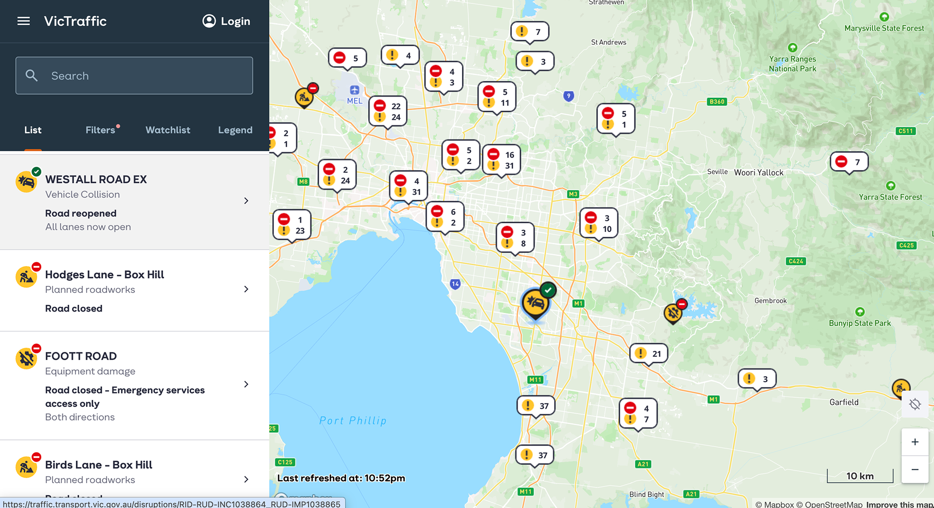
VicTraffic provides official information about road closures, incidents and disruptions across Victoria.
During bushfires, floods and severe weather events, people use the service to understand which roads are open, where conditions are changing and whether it is safe to travel. Emergency responders, councils, essential services, freight operators and media organisations also rely on the same information.
The redevelopment began after the 2019 and 2020 bushfires exposed serious gaps in how road closure information was collected, shared and communicated.
I led the customer experience strategy and user experience work, connecting research with the public, emergency services and transport stakeholders to the design of the new VicTraffic website and progressive Web App together with the road-information systems behind the service.
At a glance
Organisation
Department of Transport and Planning
Department of Transport and Planning
Project focus
Public safety, road information and digital service transformation
Public safety, road information and digital service transformation
My role
CX Strategy and UX Lead
CX Strategy and UX Lead
Project stages
Discovery, strategy, design, testing, launch and continuous improvement
Discovery, strategy, design, testing, launch and continuous improvement
My contribution
•Research strategy and planning
•Customer and stakeholder research
•Emergency management engagement
•Research synthesis
•Behavioural archetypes
•Journey mapping and co-design
•Prototyping and usability testing
•Benchmark study design
•Feature prioritisation
•Road information ecosystem mapping
•Council onboarding and training
•Research strategy and planning
•Customer and stakeholder research
•Emergency management engagement
•Research synthesis
•Behavioural archetypes
•Journey mapping and co-design
•Prototyping and usability testing
•Benchmark study design
•Feature prioritisation
•Road information ecosystem mapping
•Council onboarding and training
The challenge
VicTraffic was created in 2013 to provide information about road disruptions across Victoria.
During the 2019 and 2020 bushfires, communities were surrounded by fire, roads were closed and conditions changed rapidly.
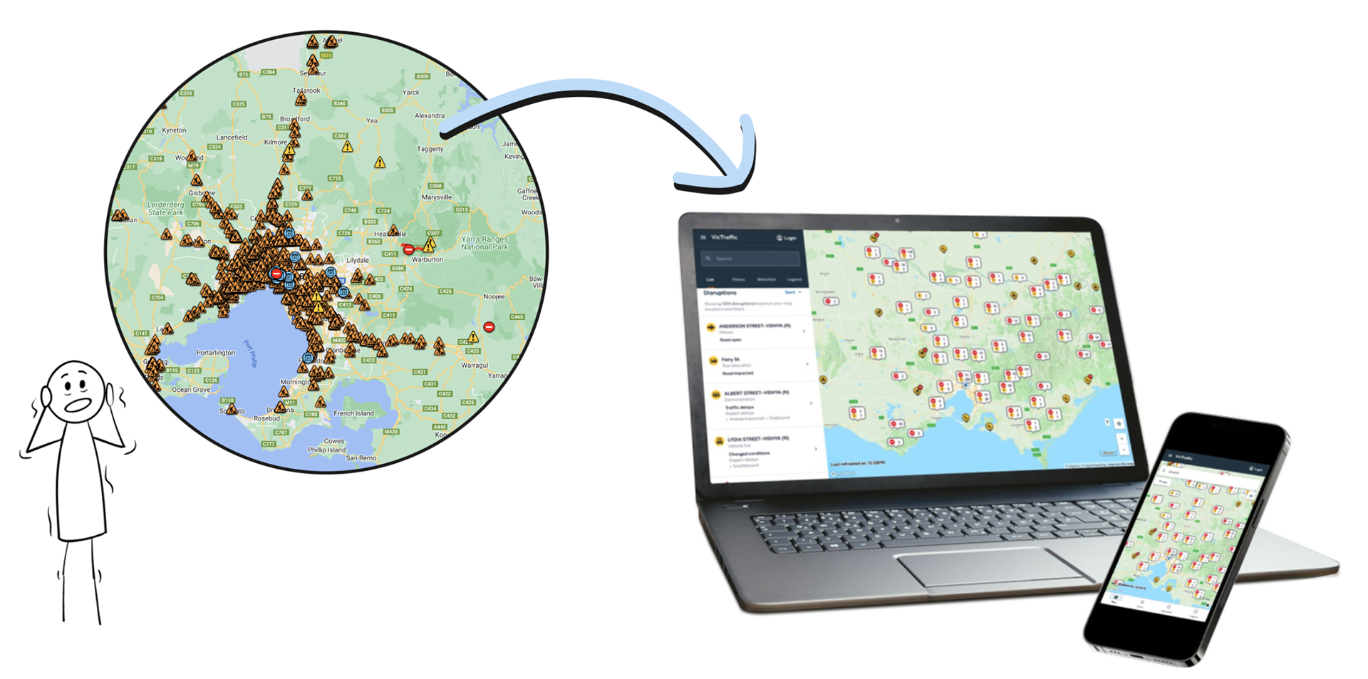
People trying to leave or return to affected areas could not always determine whether a road was open. Some drivers relied on general navigation tools that continued directing them towards dangerous or inaccessible routes.
Emergency responders and transport teams faced a different challenge. Road information was collected across multiple organisations and systems, and updates could be delayed, duplicated, incomplete or out of date.
The existing VicTraffic platform was not prepared for the scale and urgency of a widespread emergency.
The project needed to address several connected problems:
•Helping the public make safer travel decisions
•Providing emergency responders with current operational information
•Collecting consistent road-closure data across the state
•Including local council roads
•Reducing outdated and duplicated information
•Supporting people before, during and after an emergency
•Rebuilding trust in VicTraffic as the official source of road information
•Providing emergency responders with current operational information
•Collecting consistent road-closure data across the state
•Including local council roads
•Reducing outdated and duplicated information
•Supporting people before, during and after an emergency
•Rebuilding trust in VicTraffic as the official source of road information
The redevelopment was informed by recommendations from the Royal Commission into National Natural Disaster Arrangements, which called for current road closure and reopening information to be available publicly across all roads.
Setting the strategy
I initiated the customer experience strategy by bringing together the business objectives, stakeholder expectations, customer needs, Royal Commission recommendations and the technical limitations of the existing systems.
I developed a research plan that defined:
•Research objectives
•Research methods and activities
•Participant recruitment
•Required research artefacts
•Delivery timelines
•How the findings would inform the project roadmapThe work established a shared basis for understanding the problem and prioritising requirements across the wider VicTraffic project suite.
•Research methods and activities
•Participant recruitment
•Required research artefacts
•Delivery timelines
•How the findings would inform the project roadmapThe work established a shared basis for understanding the problem and prioritising requirements across the wider VicTraffic project suite.
Understanding who relies on VicTraffic
The organisation initially believed that the general public was the main audience for VicTraffic.
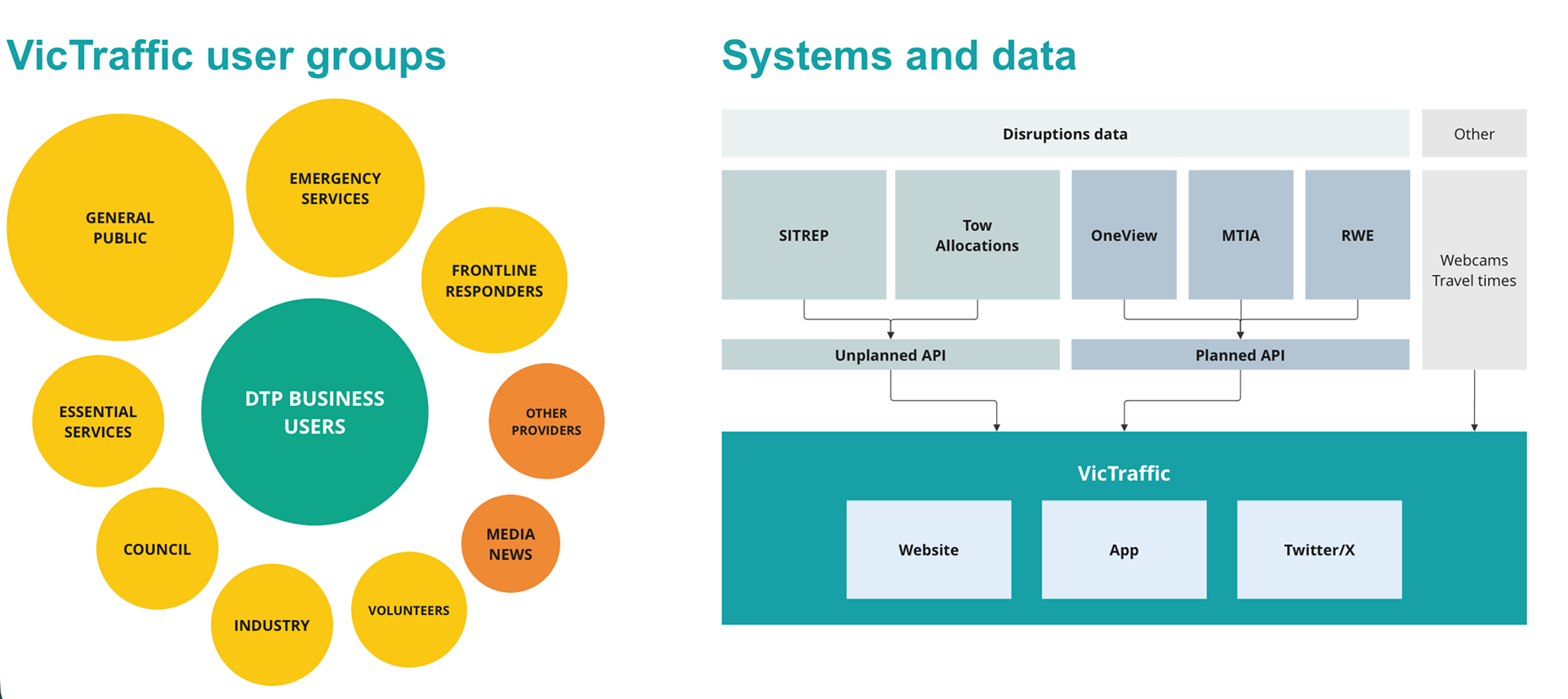
The research showed that the service supported a much wider range of users, including:
•Members of the public
•People living in emergency-affected communities
•Emergency responders
•Transport and road authorities
•Local councils
•Essential service providers
•Freight and heavy vehicle operators
•Industry and frontline workers
•Media organisations
•People living in emergency-affected communities
•Emergency responders
•Transport and road authorities
•Local councils
•Essential service providers
•Freight and heavy vehicle operators
•Industry and frontline workers
•Media organisations
During major events, media outlets regularly direct people to VicTraffic as the official source for current road closure information.
Each group had different responsibilities, but they shared a need for information that was timely, accurate and easy to act on.
Residents needed to know whether they could leave or return home.
Emergency responders needed routes that allowed them to reach incidents quickly and safely.
Freight operators needed to understand closures, bridge heights, road loads and whether they could reroute large vehicles.
Councils and transport authorities needed a reliable way to communicate changes across the road network.
The research helped the project move beyond designing for a general road user and develop an experience that reflected different behaviours, responsibilities and levels of urgency.
It was essential to understand what people experienced while travelling during major emergencies.
I conducted research with people who had lived experience of:
•The 2019 and 2020 bushfires
•The 2021 and 2022 floods
•The 2021 severe weather event in the Dandenong Ranges
•Road closures and limited access during high-impact events
•The 2021 and 2022 floods
•The 2021 severe weather event in the Dandenong Ranges
•Road closures and limited access during high-impact events
Research approach
I developed the customer experience strategy and research plan, bringing together customer needs, Royal Commission recommendations, business priorities, stakeholder expectations and the limitations of legacy systems. The findings informed requirements and prioritisation across the wider VicTraffic roadmap.
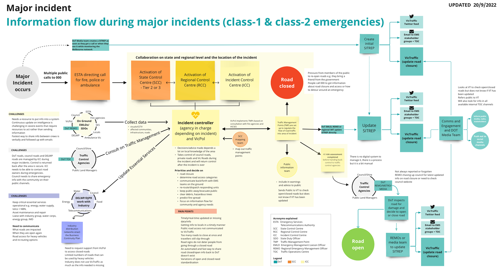
Mapping the road information ecosystem
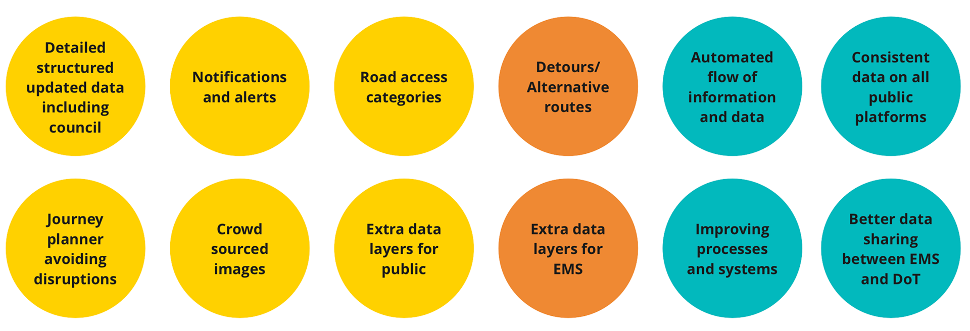
VicTraffic depends on information from multiple systems, organisations and planned and unplanned disruption sources.
The previous service was affected by:
•Outdated information
•Duplicated records
•Incomplete road closure data
•Inconsistent information between organisations
•Manual data entry and communication
•Delays between an event occurring and appearing publicly
•Gaps in local council road information
•Duplicated records
•Incomplete road closure data
•Inconsistent information between organisations
•Manual data entry and communication
•Delays between an event occurring and appearing publicly
•Gaps in local council road information
I worked with emergency management organisations and Department of Transport and Planning stakeholders to map how road closure information moved through the ecosystem.
The map showed:
•Where information originated
•The organisations involved
•How updates were communicated
•Where manual processes created delays
•Where information could be lost or duplicated
•How backend issues affected the public experience
•The organisations involved
•How updates were communicated
•Where manual processes created delays
•Where information could be lost or duplicated
•How backend issues affected the public experience
This work demonstrated that the quality of the website depended on the systems, processes and data behind it.
The findings also informed the team responsible for replacing the outdated incident-management system and helped shape requirements for the Roads Incident Database.
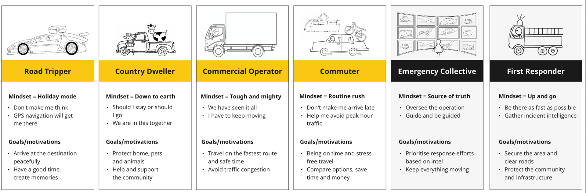
Mindset personas
Six mindset personas emerged from the discovery research.
The public, emergency responders and service organisations had different goals and motivations, but shared many of the same needs for road and traffic information.
The mindset personas helped the project team understand what each group needed:
•Before an emergency
•While planning a journey
•During an emergency
•When a route became unavailable
•When conditions changed
•When information was uncertain
•After an event
•While planning a journey
•During an emergency
•When a route became unavailable
•When conditions changed
•When information was uncertain
•After an event
The team used these insights to identify requirements and prioritise features according to customer value, emergency impact, technical feasibility, available data, development effort and funding.
This ensured that feature decisions were based on behaviour and evidence rather than assumptions.
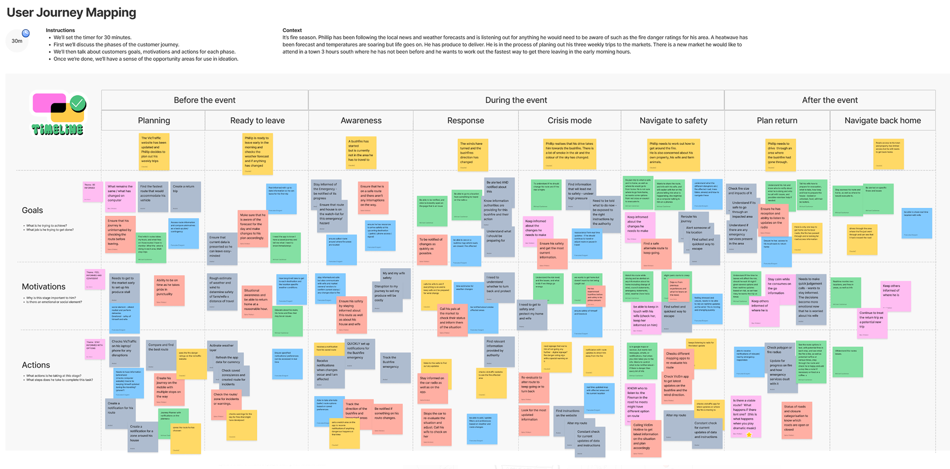
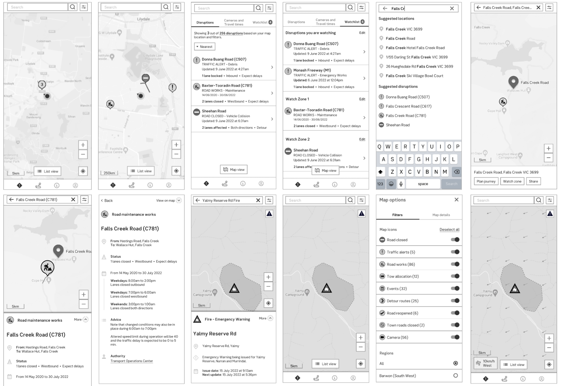
Bringing the future experience to life
The team created a future-state video combining emergency reporting, research-based scenarios and dramatised experiences.
It helped stakeholders understand the consequences of unreliable road information and showed how notifications, watch areas, localroad data and richer operational information could create a safer and more trusted service
Establishing a measurable baseline
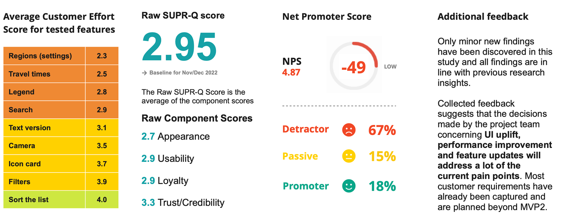
I designed a repeatable benchmark study to measure the customer experience of the existing VicTraffic website and create a baseline for evaluating the redevelopment.
The study included:
•Moderated interviews
•Self-moderated website testing
•A customer survey
•Self-moderated website testing
•A customer survey
The baseline study was conducted between November 2022 and January 2023.
Participants included existing VicTraffic users and people who were new to the service. They completed selected tasks using the old website so we could establish clear baseline measures.
The study was designed so the same tasks and measures could be repeated after launch.
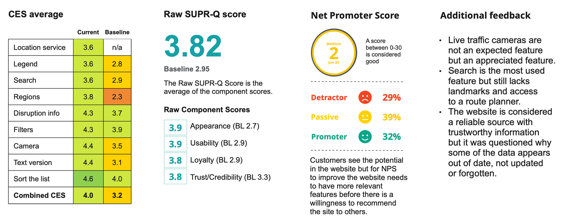
The repeated study was conducted between March and May 2023 after the minimum viable product was released.
It showed significant improvement across:
•Customer Effort Score
•Standardised User Experience Percentile Rank Questionnaire
•Net Promoter Score
•Standardised User Experience Percentile Rank Questionnaire
•Net Promoter Score
The findings gave the project team evidence that the new experience was easier to use and better received than the service it replaced.
Benchmark results – existing (old) website
Benchmark results – after MVP launch
Improving the data behind the website
One of the most important research findings was that the public experience could not be improved without addressing the quality and completeness of road closure data.
The Roads Incident Database, known as RID, was created as a central system for collecting road closure information from across Victoria.
RID connects to VicTraffic and supplies the information displayed on the public website.
A significant gap in the previous service was that local council road closures were often missing. This meant people could see information about state-managed roads without receiving the full picture of disruptions across local road networks.
RID enabled Victorian councils to log in and enter local road closure information directly.
This helped improve the completeness of the information available through VicTraffic and supported the Royal Commission recommendation to include closures across all roads.
Onboarding Victorian councils
Introducing RID required more than building a new system.
Councils needed to understand:
•Why RID was being introduced
•How local road information would be used
•How to enter and maintain disruption records
•How the information would appear on VicTraffic
•Their role within the wider information ecosystem
•How local road information would be used
•How to enter and maintain disruption records
•How the information would appear on VicTraffic
•Their role within the wider information ecosystem
I played an instrumental role in onboarding Victorian councils to RID.
Working with the Change Manager, I helped create training materials, translated system processes into clear guidance and delivered training sessions for council staff.
The sessions helped participants understand both how to use the system and why the quality of their data mattered to the public experience.
This extended my contribution from research and digital experience design into service implementation, capability building and operational change.
Outcomes
The redevelopment created a more usable and trusted road information service for Victoria.
Key outcomes included:
•A public experience grounded in evidence from real emergency events
•Significant improvements in CES, SUPRQ and NPS
•Clearer access to road closure and disruption information
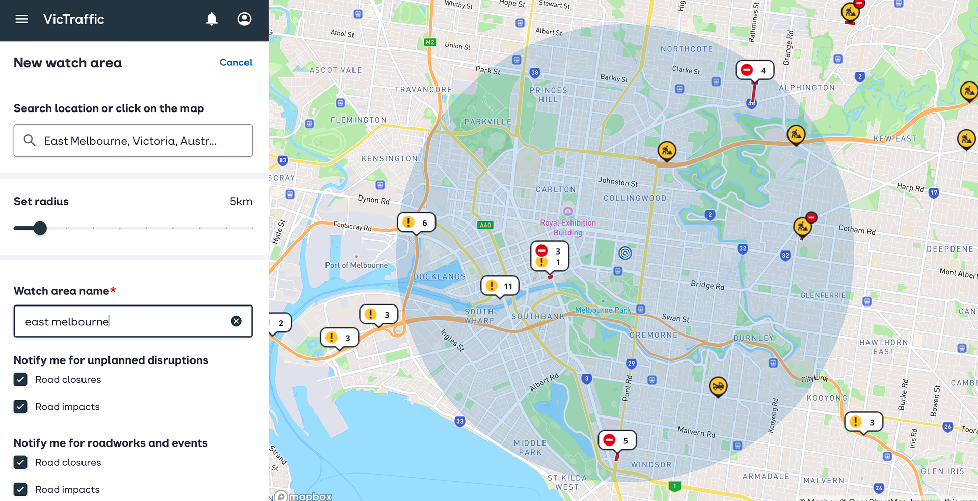
•Personalised watch areas and notifications
•A Progressive Web App replacing the older mobile app
•Stronger connections between the public website and backend data
•A central Roads Incident Database
•The inclusion of local council road closure information
•Council onboarding and training
•A clearer roadmap for ongoing development
•Significant improvements in CES, SUPRQ and NPS
•Clearer access to road closure and disruption information
•Personalised watch areas and notifications
•A Progressive Web App replacing the older mobile app
•Stronger connections between the public website and backend data
•A central Roads Incident Database
•The inclusion of local council road closure information
•Council onboarding and training
•A clearer roadmap for ongoing development
VicTraffic continues to be promoted as the official source for road closure information during bushfires, floods and severe weather.The service supports the public, emergency responders, essential services, councils, freight operators and media organisations when accurate information is critical.
VicTraffic continues to support road users and emergency responders across Victoria.
Its role becomes especially visible during bushfires, floods and severe weather, when official and media communication directs the public to the service for current road closure information.
Award recognition
iTnews Benchmark Awards
VicTraffic was named a finalist in the Best State Government Project category at the 2025 iTnews Benchmark Awards.
The project was recognised as:
VicTraffic: Real-time emergency and traffic information for Victorian road users
This recognition reflected the scale and public value of the transformation, connecting the redesigned public service with improved emergency information, road-closure data and operational processes across Victoria.
2024 DTP People Award
VicTraffic and the Roads Incident Database received internal recognition from the Department of Transport and Planning and were nominated for a 2024 DTP People Award.
The project teams were recognised for delivering strategic and operational reform within budget and meeting project objectives by improving road-closure information across Victoria.
My role and contribution
My role connected customer strategy, research, experience design, measurement and implementation.
I led discovery and prototyping, established the benchmark study, mapped the road information ecosystem, informed the RID requirements and supported councils through onboarding and training.
What I learned
VicTraffic reinforced that a trusted public service depends on much more than its interface.
People need clear and usable information, but the experience is only as reliable as the data, processes and organisations behind it.
The research showed that gaps in road information could affect real decisions during dangerous conditions. Accuracy, timeliness and clarity were therefore essential service requirements.
The project also demonstrated the value of combining discovery research with repeatable measurement.
The benchmark study allowed the team to show that the new experience represented a meaningful improvement, while continued feature testing kept future development connected to customer evidence.
My work with RID and Victorian councils strengthened my understanding of service implementation. Improving the website required change across technology, operational processes, organisational participation and user capability.The future-state video also demonstrated the value of storytelling. It helped stakeholders understand the human consequences of the service problem and connect technical improvements to real situations.
Related work
Roads Incident Database
Creating the data and operational foundation for more complete road closure information across Victoria.
Multi-Modal Journey Planner
Understanding how people plan and adapt journeys across different transport modes.